Surfaces and Contour Plots
Part 6: Contour Lines
A contour line (also known
as a level curve) for a given surface is the curve of intersection of
the surface with a horizontal plane, z = c. A representative
collection of contour lines, projected onto the xy-plane, is a contour
map or contour plot of the surface.
In particular, if the surface is
the graph of a function of
two variables, say z = f(x,y), then the contours
are defined implicitly by equations of the form f(x,y) = c,
z = c. The projections into the xy-plane that
make up the contour map are defined by f(x,y) = c,
z = 0, again for a representative collection of constants c.
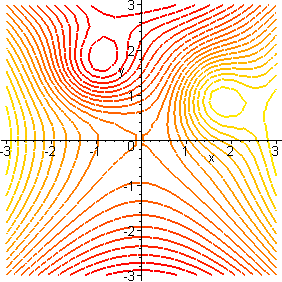
In the following figure, we show a conventional plot of a function graph on
the left and the corresponding contour map on the right. In this map, colors
are used to show different elevations, lighter colors at the higher elevations.
- Make sure you understand how the
contour map represents the function in the figure above. How can you tell
from the contour map where there is a "peak" on the surface? a "valley"?
a "saddle point"? [A saddle point is a level spot from which you
can go down in some direction and up in some other direction.] Give approximate
xy-coordinates for each of these three features.
- Write down the equations of level
curves for f(x,y) = x2 + y2
for four values of c. Plot this surface and these level curves in your
worksheet. If your computer algebra system has a contour option, use it to
draw contour lines both on the surface and projected into the xy-plane.
Contour plots are used extensively
in geography to indicate the height of the ground above a point on a map. Such
maps are called topographical maps. The following figure is an example.
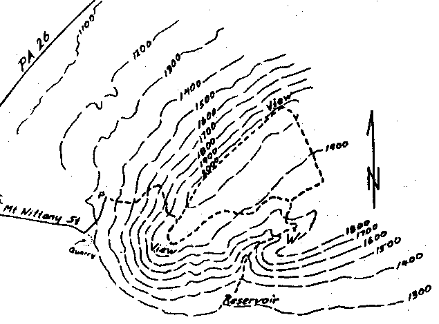
- Identify a mountain top in the
topographical map shown in the figure above. How can you use contours to be
sure of this? How can you distinguish between relatively steep places on the
mountain slope from not-so-steep places?
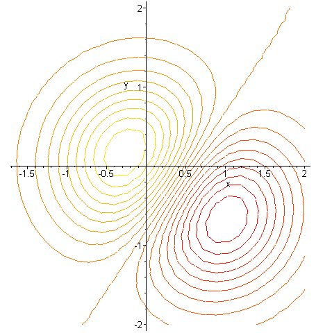
- The figure below shows a contour
plot of a mathematical function. As in our first example, the lighter contours
represent higher elevations. Make a sketch of the surface on paper, as best
you can. Then use the commands in your worksheet to plot the function from
which this map was made. How well did you read the map?
- In your worksheet
make a contour plot for the function f(x,y) = 3 - x2 - 2y2,
identifying at least four level curves. What are the shapes of these
level curves?
- Make a contour plot
for the Cobb-Douglas function f(x,y) =
 over 0 < x < 2, 0 < y < 2,
identifying at least four level curves. What are the shapes of these
level curves? How do you know?
over 0 < x < 2, 0 < y < 2,
identifying at least four level curves. What are the shapes of these
level curves? How do you know?
| CCP
Home | Materials | Multivariable
Calculus | Module Contents | Back
| Forward |